It takes 2 full days to reach Mfangano Island from the US. From Europe, most planes land in Nairobi. From Nairobi you can travel by bus or plane to Kisumu in Western Kenya. From Kisumu you can take a Matatu to Luanda Kotieno where the ferry will carry you across Kavirondo Gulf to Mbita Point. From Mbita it takes 2 hours to travel by boat out to Mfangano Island.
Map of Geologic History and Fault Lines
Lake Victoria lies at the center of the Great Rift Valley, a massive fault line that runs North to South from present day Israel to South Africa. (Courtesy of Emily Lowery)
Lake Victoria's Heart
Mfangano is located near the international boundary waters of Kenya, Uganda, and Tanzania
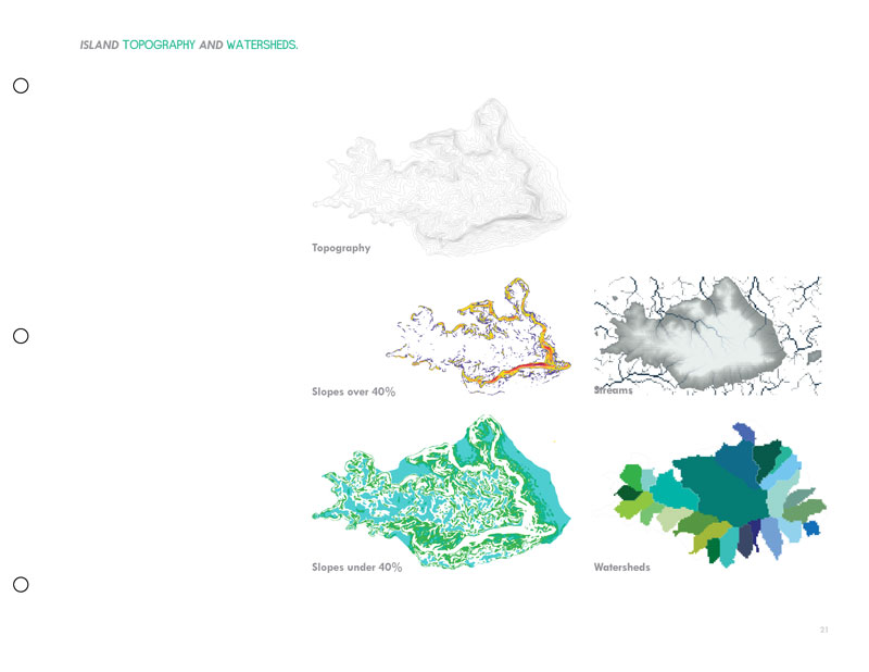
Topographical Map of Mfangano Island
Mfangano Island climbs sharply out Lake Victoria which sits at 1100m above sea level. The highest point on Mfangano Island is Soklo mountain rising 573 meters from the surface of Lake Victoria to an altitude of 1673m above sea level
Nile Perch Central
Mfangano Island is surrounded by some of the deepest water in Lake Victoria, ideal Nile Perch breeding and feeding grounds. This marks Mfangano as one of the premier Nile Perch fishing locations in the world, and ground zero for the Nile Perch export industry. (Image Courtesy of Jennifer Johnson, 2008. “Of Darwin’s Dreams and Nightmares: The Concealed Violence of a Global Whitefish Commodity.” School of Natural Resources and Environment: University of Michigan PhD and Master’s Thesis Collection; 1-45. http://hdl.handle.net/2027.42/58200 accessed on November 15th, 2008.)
The Flight of the Abakunta
The people of Mfangano Island today are direct descendants of the Abakunta, a group of Bantu clans who fled Uganda ~15 generations ago (~1750 AD).
Mfangano Lineages
People on Mfangano can trace their family trees back to one of several original ancestors who fled from Uganda. (From Kenny, Michael. 1977. “The Relation of Oral History to Social Structure in South Nyanza, Kenya” Africa: Journal of the International African Institute Vol 47, No. 3; 276-288)
An Endangered Language
Suba is a Bantu language spoken only along the shores of Lake Victoria. There are fewer than 100,000 native Suba speakers alive today. Assimilation, political repression, and economic trade with the dominant Luo people have led to a slow and steady decline. In the last 30 years, HIV/AIDS has had a devastating impact on this language. OHR is working hard to protect this endangered language and unique cultural identity. (From Rottland Franz, and Duncan Okoth Okombo. 1992. “Language Shift Among the Suba of Kenya.” from Language Death: Factual and Theoretical Explanations with Special Reference to East Africa. Matthias Brenzinger, ed. Mouton de Bruyter. New York.)
HIV Prevalence in Kenya
Lake Victoria has the highest HIV prevalence in Kenya.
HIV Prevalence in Nyanza
Suba District has the highest HIV prevalence in Nyanza (from International Medical Corps. 2008. “Annual Report of HIV Voluntary Counseling and Testing Data from Mfangano Island, Suba District, Kenya.”)
Record Breaking WIFI Link
In 2012, OHR and Inveneo activated East Africa's longest WIFI link, 90-km from the rooftop of a skypscraper in Kisumu to a wind-powered communications tower on top of Soklo mountain...